Post Processing Kinematic is used when sub-centimeter position accuracy is required, but when there is no possibility to measure with this accuracy in real-time. Real Time Kinematic might not be possible when you are surveying in a remote area, where you do not have access to Internet or a cellular network to get correction data into your GNSS receiver. In these cases you record the raw satellite observations using your GNSS rover and corrections will be applied after the survey by downloading correction (RINEX) data from a nearby base station.
When using PPK in Hydromagic, make sure that, even when the accuracy is low and the raw satellite observations are recorded by your rover, you still continue to record the position data in Hydromagic. These position records will later be merged with the PPK position data generated by, for instance, the RTKPOST utility of RTKLib.
The PPK processing tool part of the "Sounding Wizard" and can be found in the tools collection page. To start the PPK processing tool, just click the "Process..." button in the "PPK Processing" section as shown below:
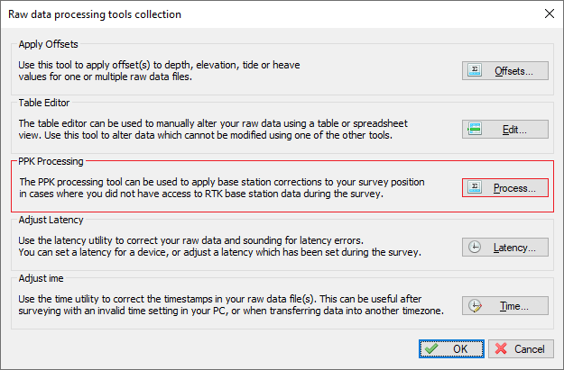
The PPK processing tool can be found in the tools collection of the "Sounding Wizard".
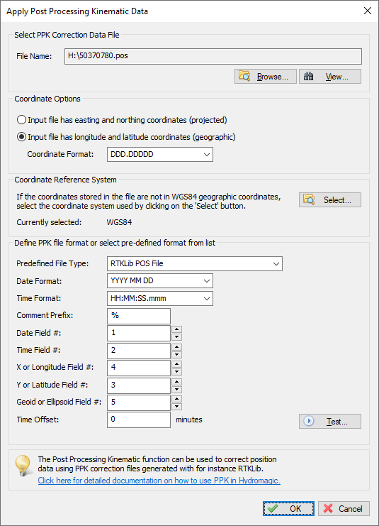
In the PPK processing tool you have to select the PPK file to use. Since there are numerous different PPK file formats, you have to specify the layout used in the file. By default the settings for RTKLib files are loaded:
The PPK processing tool can be found in the tools collection of the "Sounding Wizard".
The first step is to select an input file by clicking the "Browse..." button. After selecting the file, you can use the "View..." button to inspect the contents of the file. This should look like the example below, when you did use the free RTKLib software to generate your PPK correction file(s):
% program   : RTKPOST ver.2.4.3 b33
% inp file  : H:\RINEX\50370790.20o
% inp file  : H:\RINEX\nieu079l.20o
% inp file  : H:\RINEX\50370790.20*
% obs start : 2020/03/19 11:48:39.0 GPST (week2097 388119.0s)
% obs end   : 2020/03/19 11:53:43.0 GPST (week2097 388423.0s)
% pos mode  : kinematic
% freqs     : L1+L2
% solution  : combined
% elev mask : 10.0 deg
% dynamics  : off
% tidecorr  : off
% ionos opt : broadcast
% tropo opt : saastamoinen
% ephemeris : broadcast
% amb res   : fix and hold
% val thres : 3.0
% antenna1  :                       ( 0.0000  0.0000  0.0000)
% antenna2  :                       ( 0.0000  0.0000  0.0000)
% ref pos   : 52.587204096    6.281890713    61.3318
%
% (lat/lon/height=WGS84/ellipsoidal,Q=1:fix,2:float,3:sbas,4:dgps,5:single,6:ppp,ns=# of satellites)
%  GPST                  latitude(deg) longitude(deg)  height(m)   Q  ns   sdn(m)   sde(m)   sdu(m)  sdne(m)  sdeu(m)
2020/03/19 11:48:39.000   52.553810731    6.062372670    44.3737   1   8   0.0049   0.0032   0.0075  -0.0023  -0.0017
2020/03/19 11:48:40.000   52.553810753    6.062372617    44.3673   1   8   0.0050   0.0034   0.0079  -0.0023  -0.0016
2020/03/19 11:48:41.000   52.553810756    6.062372676    44.3731   1   8   0.0051   0.0035   0.0078  -0.0023  -0.0014
2020/03/19 11:48:42.000   52.553810713    6.062372680    44.3719   1   8   0.0051   0.0034   0.0079  -0.0024  -0.0015
2020/03/19 11:48:43.000   52.553810713    6.062372678    44.3759   1   9   0.0048   0.0030   0.0073  -0.0021  -0.0019
2020/03/19 11:48:44.000   52.553810728    6.062372678    44.3817   1   9   0.0054   0.0037   0.0085  -0.0022  -0.0018
2020/03/19 11:48:45.000   52.553810720    6.062372688    44.3844   1   9   0.0053   0.0036   0.0085  -0.0022  -0.0018
2020/03/19 11:48:46.000   52.553810696    6.062372709    44.3813   1   9   0.0053   0.0037   0.0085  -0.0022  -0.0018
2020/03/19 11:48:47.000   52.553810730    6.062372702    44.3882   1   9   0.0053   0.0037   0.0085  -0.0021  -0.0018
2020/03/19 11:48:48.000   52.553810723    6.062372714    44.3839   1   9   0.0053   0.0036   0.0085  -0.0021  -0.0018
2020/03/19 11:48:49.000   52.553810722    6.062372721    44.3861   1   9   0.0053   0.0036   0.0085  -0.0023  -0.0017
2020/03/19 11:48:50.000   52.553810710    6.062372722    44.3820   1  10   0.0067   0.0042   0.0100  -0.0029  -0.0034
Example of a PPK correction file as generated using RTKPOST.
We will explain the different settings by using the example above. In the Hydromagic PPK processing tool you have to specify the field indexes, as well as the coordinate, date and time field formats, so it knows which field represents which value. Looking at the example above, you can see that the date is the first field, the time is the second field, the latitude coordinate in the third field, the longitude coordinate in the fourth field and finally the elevation is in the fifth field. Configure this field order first. Please note that this setting may be different depending on the tool you are using to generate PPK correction files:
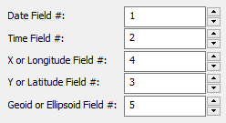
Set the field indexes according to the field
assignment in the PPK correction file.
Some files are writing comments at the start of the file as well. You can see in the example above, that the RTKPOST utility uses a percent sign to mark comment lines. We have to tell Hydromagic to skip those lines, so we enter a percent sign as "Comment Prefix" setting. Also make sure to set the "Date Format" and "Time Format" settings, so they match the time and date format used in the correction file. This is a very important setting, since the records are matched with Hydromagic raw data file records by using the time and date stamps.
While this is not the case when using RTKLib, it might be possible to encounter a file where the coordinates are stored as projected easting and northing coordinates. In this case, select the "Input file has easting and northing coordinates" option in the "Coordinate Options" section. You also need to click the "Select..." button in the "Projection" section to tell the software in which coordinate reference system those coordinates are.
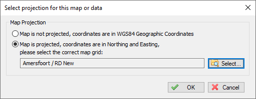
Select the projection in case of projected coordinates, otherwise set to "WGS84".
When you have configured all the settings in the PPK processing dialog, please click the "Test..." button before applying the corrections to your raw data file(s). The software will now try to parse the correction file and shows the first 500 records of information found in the file. Make sure the timestamps and the latitude/longitude/elevation values are correct. When this is the case, it is safe to click the "OK" button to apply the correction data to your raw data file(s).

Test the settings before applying the corrections to your raw data files - Example test result file shown above.
After testing the settings, click the "OK" button to apply the settings. Please note that the corrections will be applied to the modified raw data files only. Your original raw data files will stay intact, so you can always roll back the PPK actions by starting the "Sounding Wizard" with the original data. The software will open a notepad files that shows a report of the affected position records along with the shift in position after correction.
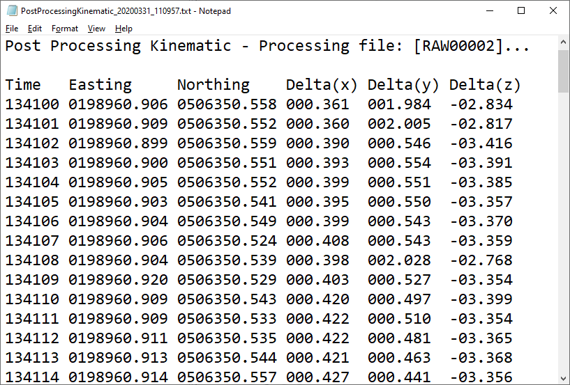
After applying the correction data, a record showing the affected position records will be opened in notepad.