The main goal of the "Geoid Converter" software is to enable Hydromagic users to convert third-party geoid files to a format which can be read by the Hydromagic software. There are so many different geoid file formats around that we decided to use our own format, and create an external tool to get files converted to our internal format.
The following geoid file formats are currently supported:
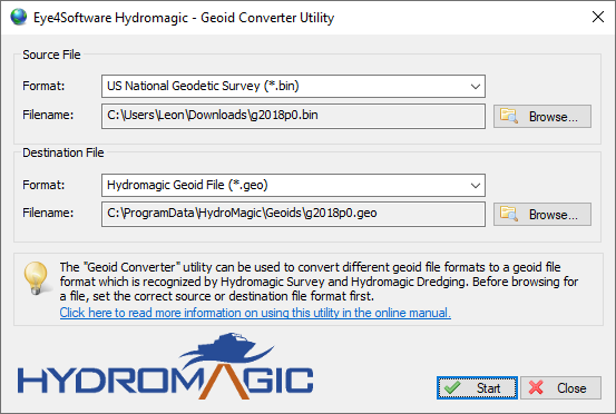
The "Geoid Converter" utility allows you to convert geoid data to the Hydromagic geoid file format.
The tool is installed in the "Program" folder under the installation folder of the software. It can be started using Windows Explorer, or by locating the software under the Windows Start Menu. Alternatively, you can start the "Geoid Converter" utility by selecting "External Tools" => "Geoid Converter..." option from the "Tools" menu in Hydromagic Survey.
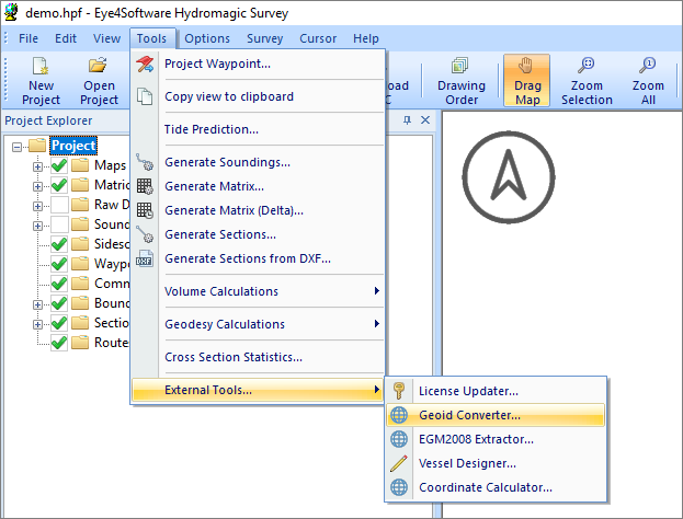
The "Geoid Converter" utility can be launched from the "Tools" menu.
Converting geoid files with the "Geoid Converter" Utility is very straightforward. All you have to do is to select a source format. The destination format of the data will always be the "Hydromagic Geoid File (*.geo)" file format which can be used in Hydromagic to use RTK tides.
After selecting the formats, use the "Browse..." buttons to select an input and output file. In order to use geoid files in Hydromagic, the destination file has to be written in the Hydromagic "Geoids" folder which is selected by default.
When done, click the "Start" button and the conversion process should start. Converting a single file usually only takes a couple of seconds.
The Geoid File Conversion Utility supports two ASCII geoid file formats at this moment. Because there are a lot of different types of ASCII geoid files, the types supported are described in the next chapters. When encountering an ASCII format not yet supported, please contact our support desk so we can check if it is worth implementing this format in the conversion utility.
You should use this option for a file which contains a header value contained by separation values for each cell. The header contains six values in the following order: South boundary, north boundary, west boundary, east boundary, vertical cell size and horizontal cell size.
    27.00000    36.97500   -14.00000    -0.02500     0.02500     0.02500
    52.383    52.342    52.302    52.257    52.205    52.147    52.073    51.978
    51.864    51.742    51.619    51.498    51.378    51.261    51.144    51.029
    50.916    50.805    50.695    50.588    50.484    50.391    50.301    50.212
    50.122    50.029    49.930    49.821    49.700    49.571    49.437    49.298
    49.155    49.006    48.853    48.697    48.539    48.379    48.220    48.063
    47.912    47.767    47.631    47.503    47.385    47.275    47.175    47.083
    46.998    46.917    46.838    46.760    46.682    46.606    46.534    46.469
This option is used for geoid files which consist entirely out of ASCII XYZ pairs as shown in the example below. These files do not have a header and calculate the number of rows, columns, boundaries and cell sizes directly from the XYZ records in the file.
    41449.795 3845328.858 24.700
    43449.799 3845328.878 24.613
    45449.803 3845328.897 24.516
    47449.807 3845328.916 24.429
    49449.811 3845328.935 24.342
    51449.815 3845328.954 24.255
    53449.819 3845328.973 24.178
    55449.823 3845328.992 24.091
    57449.827 3845329.012 24.004
    59449.831 3845329.030 23.917
    61449.835 3845329.049 23.830
    63449.839 3845329.068 23.743
The French MNT format is used by the IGN in France to store geoid models for the French mainland, as well as French overseas territories like: Guadeloupe, Martinique, French Guiana, Mayotte and Reunion. The direction in which the ellipsoidal heights are stored differ and depends on the area. This direction is encoded in the file header. Below is an example of a MNT file:
    44.910 45.405 -13.095 -12.420 0.045 0.045 4 1 1 1 0. Mayotte SHOM 1953
    44.91    -13.095 -20.852 99
    44.91    -13.05  -20.653 99
    44.91    -13.005 -20.439 99
AusGeoid files are ASCII files used to store Australian Geoid models like AUSGeoid93, AUSGeoid98, AUSGeoid09 and AUSGeoid2020. Although most of these models are already available in Hydromagic format, you might want to convert files by your own. More information on the AUSGeoid can be found on the "Geoscience Australia" website (http://www.ga.gov.au/ausgeoid/). Below is an example of a AUSGeoid file:
    AUSGeoid09_GDA94_V1.01                          www.ga.gov.au
    GEO   -2.493 S39  0  0.000 E143  0  0.000     -6.19     -5.86
    GEO   -2.452 S39  0  0.000 E143  1  0.000     -6.24     -5.79
    GEO   -2.411 S39  0  0.000 E143  2  0.000     -6.19     -5.86
    GEO   -2.368 S39  0  0.000 E143  3  0.000     -6.30     -5.86
    GEO   -2.328 S39  0  0.000 E143  4  0.000     -6.24     -5.71