A gnomonic map projection displays all great circles as straight lines. Thus the shortest route between two locations in reality corresponds to that on the map. This is achieved by projecting, with respect to the center of the Earth (hence perpendicular to the surface), the Earth's surface onto a tangent plane. The least distortion occurs at the tangent point. Less than half of the sphere can be projected onto a finite map. As a corollary, a rectilinear photographic lens cannot encompass more than 180 degrees for the same reason.
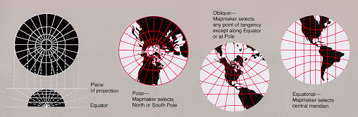
Gnomonic Projection
To convert coordinates using the Gnomonic projection, the following parameters have to be set: