The "Apply Offsets" tool can be used to apply fixed offsets to a couple of vertical measurements and horizontal measurements, including depth, tide, mean sea level, ellipsoidal height and heave. You can also correct or inverse motion data like heave, roll, pitch and heading here.
To start applying offsets to your data, click the "Offsets" button from the "Data processing tools collection" screen, which can be opened by clicking the "Tools..." button on page 5 of the sounding wizard.
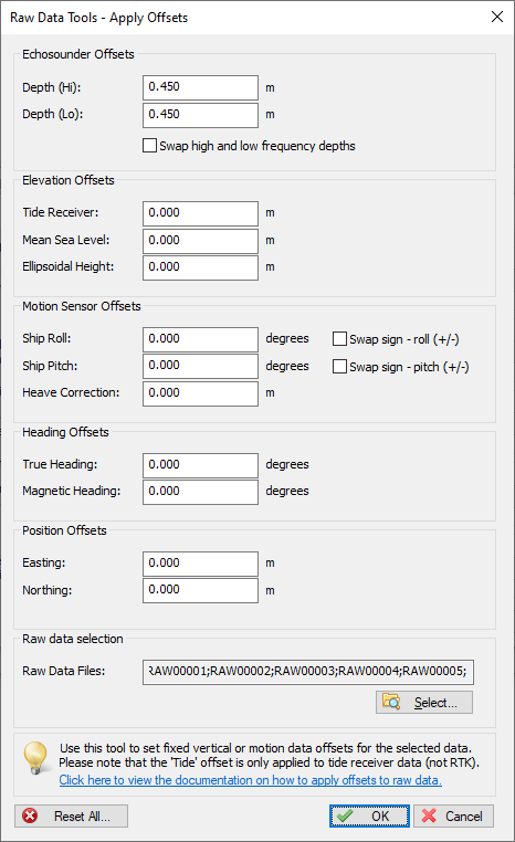
Use the offsets utility to apply various offsets to your raw data files.
Use the "Depth (Hi)" and "Depth (Lo)" fields to correct the measured high or low frequency depth(s). You can use this function, for instance, when you recorded a sounding without, or with an incorrect echo sounder transducer offset (static draft).
Use the "Tide" field to apply a fixed offset to the observed tide values. This function can be used to apply a fixed tide, or to correct your tide receiver or RTK tide measurements.
Use the "Mean Sea Level" field when you use the M.S.L. field from your GNSS receiver to calculate tide levels. This is only used in rare cases where a geoid has been programmed in the RTK receiver, and the M.S.L. field is used to output the height relative to a (local)vertical datum.
Use the "Ellipsoidal Height" field to correct the height measured by a RTK GNSS receiver. This correction can be useful when an incorrect antenna height was configured during surveys - or when you did forget to add the antenna phase center offset (can be found in the manual of your GNSS receiver or antenna).
Use the "Roll" and "Pitch" fields to correct these motion values when an IMU wasn't correctly calibrated before recording a survey. You can calibrate IMU sensors in the "Calibration" tab of the "Preferences" dialog.
Use this function to swap the angle direction of your IMU in cases where the following conventions are not met:
Positive roll value => starboard up;
Positive pitch value => stern up;
Negative roll value => port up;
Negative pitch value => bow up;
When your IMU works the other way around for one of the motion directions, check the box to invert the value before using it to correct your sounding data.
Use the "Heave" field to correct heave values in cases where the heave sensor wasn't correctly calibrated before recording a survey.You can calibrate the heave sensor in the "Calibration" tab of the "Preferences" dialog.
Allows you to correct the true heading measured by your GNSS receiver or RTK heading sensor. For instance when your heading sensor isn't mounted correctly relative to the true north.
Allows you to correct the magnetic heading measured by a magnetic compass. You can also use this setting to convert a magnetic heading to a true heading by adding the deviation.
This allows you to add a fixed offset to either the Easting and Northing (projected) coordinates in the selected raw data files. When WGS84 geographic coordinates are present in the raw data file(s) they will be corrected with the specified offsets as well.
You can apply the offsets to a single or all raw data files. In most cases, when an invalid setting was used during the entire survey, you have to apply the corrections to all files. To start processing the data, click the "OK" button. This should not take longer then a couple of seconds, depending on the size of the data.