The Mercator projection is a cylindrical map projection presented by the Flemish (Belgian) geographer and cartographer Gerardus Mercator, in 1569. It became the standard map projection for nautical purposes because of its ability to represent lines of constant course, known as rhumb lines or loxodromes, as straight segments. While the linear scale is constant in all directions around any point, thus preserving the angles and the shapes of small objects (which makes the projection conformal), the Mercator projection distorts the size and shape of large objects, as the scale increases from the Equator to the poles, where it becomes infinite.
Some projections that are derived from the Mercator projection include:
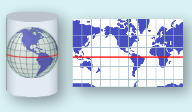
Mercator Projection
To convert Mercator coordinates, the following parameters have to be set: