
Why isn't the heading of my vessel displayed on the map view?
This can have multiple causes, but most of the time it is an issue with the GNSS receiver configuration. To fix this issue, please check the following:
- The vessel isn't moving so the GNSS receiver isn't capable of calculating the correct course over ground;
- Incorrect heading mode selected in the "Calibration" tab (true or magnetic heading);
- The heading up option is enabled, rotating the map so the vessel is always pointing north;
- The NMEA0183 VTG sentence isn't enabled in the NMEA0183 plugin;
1. The NMEA0183 VTG sentence isn't enabled on your GNSS or RTK receiver
You can easily check if this is the case by using the built-in "Device Monitor". To show this monitor, select the "Preferences..." options from the "Tools" menu and select the devices tab. Next click the NMEA0183 plugin loaded to handle the communication with your GNSS receiver and click the "Monitor..." button. After receiving some data, you can pause the monitor to see if the VTG sentence is included in your GNSS receiver data output.
2. The vessel isn't moving
A GNSS receiver calculates it's course over ground by calculating the movement between the current and previous position. When the vessel isn't moving the GNSS receiver will not output a valid course. When you see a course when the vessel isn't moving, it is because of GNSS drift or because you are using a dual antenna RTK receiver.
3. Incorrect heading mode selected in the "Calibration" tab
When you are using a GNSS receiver to calculate the course over ground, but the "Heading Mode" is set to magnetic heading, it will use a magnetic or gyro compass heading instead. When this kind of device isn't connected, you won't see a heading value. To fix this issue, select the "Preferences..." options from the "Tools" menu and select the calibration tab. In the calibration tab, verify that the "Heading Mode" is set to "Use True heading (GNSS)".
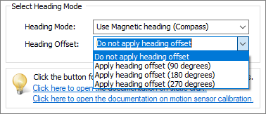
Select the preferred heading offset from the drop down list.
4. The heading up option is enabled, rotating the map so the vessel always pointing north
When the heading up option is enabled, you might still have a valid heading reading, but the map is rotating and not the vessel. If this is the case, locate the "Heading Up" button in the main toolbar and make sure it is set to disabled.
5. The NMEA0183 VTG sentence isn't enabled in the NMEA0183 plugin
The Hydromagic NMEA0183 plugins allow you to filter out a selection of NMEA0183 sentence types. When the VTG sentence has been disabled, you won't get a valid speed or heading value in the software. To check if this is the issue, select the "Preferences..." options from the "Tools" menu and select the devices tab. Next click the NMEA0183 plugin loaded to handle the communication with your GNSS receiver and click the "Configure..." button.
In the popup configuration, click the "Select Sentences..." button and make sure that the "VTG - GNSS Track made good" option has been enabled:
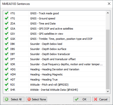
Select which NMEA0183 sentences are handled and which ones are ignored.